
Mixed-use developments have become one of the most influential real estate formats in the United States. By combining residential, commercial, retail, office, and civic functions within a single project or district, they promise something buyers, tenants, and cities increasingly demand: convenience anchored in location.
Yet mixed-use projects are also complex to explain and market. Unlike single-family homes or standalone office buildings, their value is not defined by interiors alone. It emerges from how multiple uses interact spatially—with each other and with the surrounding city. This is where location maps become essential, not decorative.
From a US market perspective, location maps are often the deciding factor in how mixed-use developments are understood, approved, financed, and ultimately adopted by users.
Why Mixed-Use Developments Are Inherently Spatial
Mixed-use developments succeed or fail based on relationships:
- Residential units relative to retail and offices
- Pedestrian paths between uses
- Transit access and parking distribution
- Integration with surrounding neighborhoods
Text descriptions struggle to capture these relationships. Floor plans explain individual components, but location maps explain the system.
In US cities, where zoning overlays, transit corridors, and neighborhood boundaries strongly influence project viability, spatial clarity is not optional. Location maps are how complexity becomes legible.
Explaining “Why Here?” to Stakeholders
Every mixed-use project faces the same early question: Why does this belong in this location?
Location maps answer that question instantly by showing:
- Proximity to employment centers
- Access to transit hubs
- Population density patterns
- Nearby amenities and institutions
For investors, these maps justify demand. For city planners, they demonstrate alignment with broader urban goals. For future residents and tenants, they explain daily convenience.
In the US approval environment, projects that clearly demonstrate locational logic encounter less resistance and faster review cycles.
Supporting Zoning and Planning Narratives
Mixed-use developments often rely on:
- Rezoning or special use permits
- Planned Unit Developments (PUDs)
- Transit-oriented development (TOD) overlays
Location maps are critical to these processes. They visually align the proposal with:
- Existing land-use patterns
- Transportation infrastructure
- Growth corridors identified in city plans
Rather than arguing compliance abstractly, developers can show compatibility. This visual alignment is particularly persuasive in public hearings and planning commission reviews, where decision-makers may not have technical backgrounds but understand maps intuitively.
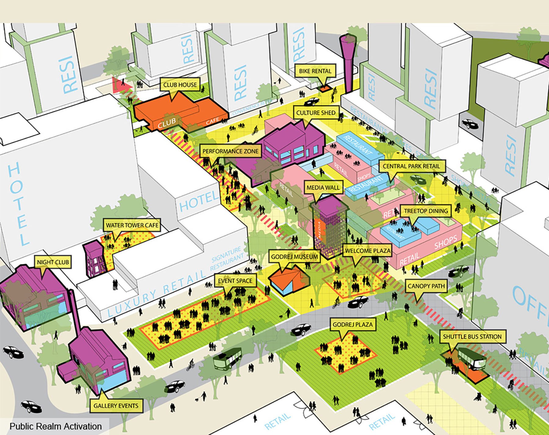
Communicating Synergy Between Uses
One of the promises of mixed-use development is synergy: residents support retail, offices support restaurants, public spaces activate foot traffic.
Location maps make this synergy visible by illustrating:
- Walking distances between uses
- Public plazas and gathering points
- Ground-floor activation zones
- Pedestrian-first circulation
In US markets, where “live–work–play” is often overused as a slogan, maps provide proof. They show whether uses truly reinforce each other or simply coexist.
Transit and Mobility as Value Drivers
Transportation access is a defining feature of successful US mixed-use projects. Buyers and tenants increasingly value:
- Rail and bus proximity
- Bike infrastructure
- Reduced car dependency
Location maps clarify:
- Transit catchment areas
- First- and last-mile connectivity
- Relationship between parking structures and walkable zones
These insights directly influence leasing velocity and pricing. A well-mapped mobility story often matters more than unit size or office floorplate efficiency.
Investor and Lender Decision-Making
From a financial perspective, mixed-use projects carry layered risk. Residential, retail, and office components may perform differently across market cycles.
Location maps help investors and lenders evaluate:
- Demand drivers for each use
- Exposure to competing developments
- Long-term neighborhood trajectories
In US capital markets, where underwriting increasingly factors in urban resilience and adaptability, spatial context strengthens credibility. Maps demonstrate that the project is not isolated but embedded in a durable location ecosystem.
Marketing to End Users: Seeing the Lifestyle
For residents, shoppers, and office tenants, mixed-use developments are lifestyle choices. Location maps allow them to visualize:
- Daily routines
- Weekend activities
- Social and cultural access
Rather than listing nearby amenities, maps show proximity. This visual immediacy shortens decision cycles and increases emotional engagement—especially in digital-first marketing environments.
In competitive US metros, projects that integrate location mapping into listings and websites consistently outperform those that rely on text-heavy explanations.
Community Engagement and Public Trust
Mixed-use developments often face community scrutiny. Concerns about traffic, noise, density, and displacement are common.
Location maps support constructive dialogue by:
- Showing buffers and transitions
- Clarifying traffic flow changes
- Identifying public amenities and open space
When communities can see how a project fits spatially, conversations shift from fear to specifics. In the US context, where public input can shape approvals, this transparency is a strategic advantage.
Phasing and Long-Term Growth
Many mixed-use projects are delivered in phases over years or even decades.
Location maps help communicate:
- Initial versus future development zones
- Infrastructure sequencing
- Temporary uses and transitions
This clarity reassures cities, investors, and neighbors that growth is intentional and managed—not speculative. It also positions the project as a long-term urban asset rather than a one-time build.
Digital Maps as Ongoing Assets
Increasingly, US developers are moving beyond static maps to interactive, data-driven location tools.
These maps:
- Evolve with the project
- Support leasing, operations, and asset management
- Continue adding value post-construction
A well-designed location map becomes part of the project’s infrastructure—supporting everything from tenant onboarding to future expansion decisions.
Conclusion: Mixed-Use Value Lives in Location Context
Mixed-use developments are not defined by any single building or use. Their value lies in relationships, access, and integration—all of which are spatial.
From a US case perspective, location maps are the most effective way to explain, justify, market, and operate these complex projects. They reduce friction in approvals, build confidence among investors, and help end users understand the lifestyle being offered.
For mapsandlocations.com, mixed-use developments represent the clearest example of why location intelligence matters. When done well, location maps do not just illustrate projects—they unlock their full potential.